
You must log in or register to comment.
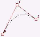
I might be a moron here, but I have no idea how to interpret this. Is each blue bar the proportion of streets that run in that direction? Do the ones that just have a single bar at N/E/S/W have perfectly aligned streets that only go in the cardinal directions?
Here’s a portion of detroit:
The city is almost entirely grid, some of it at an angle. You can see these two grids visualized in the post.
The more linear, the worse the traffic flow.
Is that your guess, or is there a specific source that says that?
https://www.sciencedirect.com/science/article/pii/S0169204623002207
Its not entirely clear, but it can be seen that traffic is worse when you have 20 traffic lights for crossroads in a row… Or at least its logical. The cities that grew over time with circular planing have better capacity even on thinner roads, meanwhile grid cities have up to 8 lane roads (4 in 4 out) very often as their main road.
Its not 100% clear but its pretty likely that its one of the factors. Another one is public transport.
Berlin’s network shape is unfortunately reminiscent of a swastika…
I guess you see what you want to see.

