haley.io
  • Communities
  • Create Post
  • Create Community
  • heart
    Support Lemmy
  • search
    Search
  • Login
  • Sign Up
The Picard Maneuver@piefed.world to CartographyAnarchy@sh.itjust.worksEnglish · 19 days ago

In case you need something to ruin your morning

media.piefed.world

message-square
52
fedilink
244

In case you need something to ruin your morning

media.piefed.world

The Picard Maneuver@piefed.world to CartographyAnarchy@sh.itjust.worksEnglish · 19 days ago
message-square
52
fedilink
alert-triangle
You must log in or register to comment.
  • anomnom@sh.itjust.works
    link
    fedilink
    English
    arrow-up
    6
    ·
    19 days ago

    But the bump is more to the right and pretty much only fits Toledo. Fuck Toledo.

  • Lemminary@lemmy.world
    link
    fedilink
    arrow-up
    3
    arrow-down
    1
    ·
    19 days ago

    Thanks, I hate you.

  • Imgonnatrythis@sh.itjust.works
    link
    fedilink
    arrow-up
    5
    ·
    19 days ago

    Guessing there is a huge Walmart there that got in the way

  • compostgoblin@piefed.blahaj.zone
    link
    fedilink
    English
    arrow-up
    11
    ·
    19 days ago

    Toledo War

  • Squibbles@lemmy.ca
    link
    fedilink
    arrow-up
    5
    ·
    19 days ago

    I looked at this on google maps and even better, when you zoom in on that top right corner of Indiana the east-west border there isn’t even a straight line. It bends slightly when it reaches the road a few hundred yards to the west

  • Wilco@lemmy.zip
    link
    fedilink
    arrow-up
    5
    ·
    19 days ago

    I hate this! Reeeeeeeee!

  • quinkin@lemmy.world
    link
    fedilink
    arrow-up
    20
    ·
    19 days ago

    • sugar_in_your_tea@sh.itjust.works
      link
      fedilink
      arrow-up
      2
      ·
      19 days ago

      Looks like it follows a river, so I’ll give it a pass. The Michigan one is just dumb.

      • toholio@lemmy.world
        link
        fedilink
        arrow-up
        3
        ·
        19 days ago

        It follows the middle of the river for part of it and the southern bank for the rest.

        • sugar_in_your_tea@sh.itjust.works
          link
          fedilink
          arrow-up
          2
          ·
          19 days ago

          Wait, why the southern bank?

          • toholio@lemmy.world
            link
            fedilink
            arrow-up
            4
            ·
            19 days ago

            There was a legal case involving the wrongful death of someone in a boat that needed the boundary better defined for jurisdictional reasons and some older documents said “the whole watercourse” was part of NSW: https://www.austlii.edu.au/cgi-bin/viewdoc/au/cases/cth/HCA/1980/11.html

    • The Picard Maneuver@piefed.worldOP
      link
      fedilink
      English
      arrow-up
      7
      ·
      19 days ago

      Ok, this is worse.

    • toholio@lemmy.world
      link
      fedilink
      arrow-up
      5
      ·
      19 days ago

      This isn’t zoomed in enough to show that the squiggly border is the middle of the river between SA and Vic. but the south bank of the river between NSW and Vic.

  • Michael@slrpnk.net
    link
    fedilink
    English
    arrow-up
    9
    ·
    19 days ago

    All borders are gore

    • [deleted]@piefed.world
      link
      fedilink
      English
      arrow-up
      5
      ·
      19 days ago

      “Am I a joke to you?”

      -Colorado

      • pez@piefed.blahaj.zone
        link
        fedilink
        English
        arrow-up
        1
        ·
        19 days ago

        Even Colorado does weird things when you look close enough.

        Along its north border with Nebraska there are lots of short curved roads connecting county roads from each state where the border seems to curve a bit too.

      • UnderpantsWeevil@lemmy.world
        link
        fedilink
        English
        arrow-up
        2
        ·
        19 days ago

      • Skua@kbin.earth
        link
        fedilink
        arrow-up
        5
        ·
        19 days ago

        Colorado has 697 sides

        • [deleted]@piefed.world
          link
          fedilink
          English
          arrow-up
          6
          ·
          19 days ago

          Congress defined the borders of Colorado as a geospherical rectangle, stretching from 37°N to 41°N latitude, and from 25°W to 32°W longitude.

          Congress declared it was a rectangle. Take that, reality!

  • AllNewTypeFace@leminal.space
    link
    fedilink
    arrow-up
    4
    ·
    19 days ago

    That’s not very kentucky.

  • ordnance_qf_17_pounder@reddthat.com
    link
    fedilink
    arrow-up
    41
    ·
    19 days ago

    Meanwhile in Belgium and the Netherlands

    • Albbi@lemmy.ca
      link
      fedilink
      arrow-up
      26
      ·
      19 days ago

    • SubArcticTundra@lemmy.ml
      link
      fedilink
      arrow-up
      3
      ·
      19 days ago

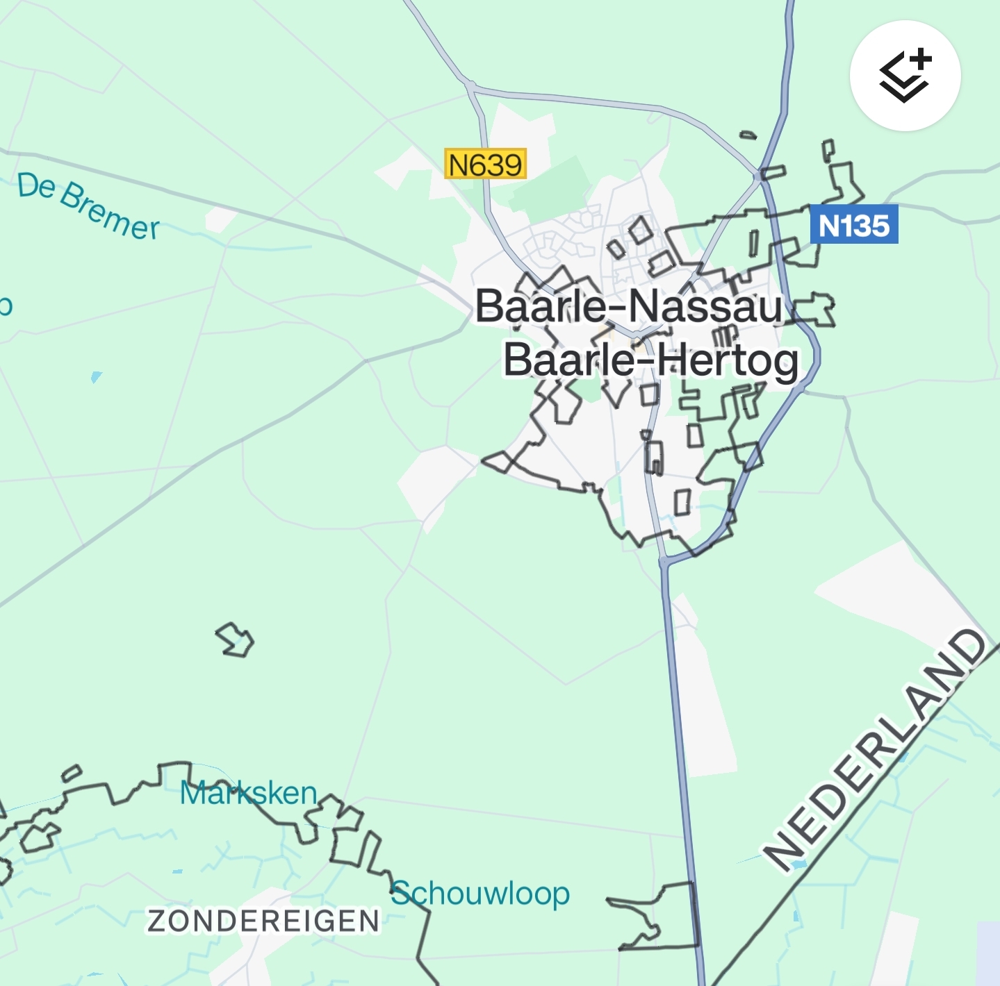
      Cartographers needed job security

    • Horsey@lemmy.world
      link
      fedilink
      arrow-up
      2
      ·
      19 days ago

      Actually a really cool place to walk around for a day. Buy fireworks then take the NS to Tilburg and get a joint in the same afternoon lol.

    • _stranger_@lemmy.world
      link
      fedilink
      arrow-up
      11
      ·
      19 days ago

      What’s so bad about that, the blue line is slightly crooked?

      Oh that’s a road.

      What are all these black lines and squares?

      Oh.

      oh no.

    • Hagdos@lemmy.world
      link
      fedilink
      arrow-up
      9
      ·
      19 days ago

      You mean in the Netherlands in Belgium in the Netherlands?

      • sawdustprophet@midwest.social
        link
        fedilink
        English
        arrow-up
        7
        ·
        19 days ago

        “You got some Netherlands in my Belgium!” “No, you got some Belgium in my Netherlands!”

        • Trainguyrom@reddthat.com
          link
          fedilink
          English
          arrow-up
          1
          ·
          19 days ago

          Why does this sound like a bit from Map Men?

  • nocturne@slrpnk.net
    link
    fedilink
    arrow-up
    48
    ·
    19 days ago

    We have our own in New Mexico.

    • [deleted]@piefed.world
      link
      fedilink
      English
      arrow-up
      6
      ·
      19 days ago

      I didn’t know about either of these and my day is now in ruins.

      • [deleted]@piefed.world
        link
        fedilink
        English
        arrow-up
        5
        arrow-down
        1
        ·
        19 days ago

        Oh no, the Montana, Wyoming, and South Dakota connection is goofy too!

        Gonna go lie down.

    • Texas_Hangover@lemmy.radio
      link
      fedilink
      English
      arrow-up
      4
      ·
      19 days ago

      Oklahoma is a pox on us all.

    • RememberTheApollo_@lemmy.world
      link
      fedilink
      arrow-up
      1
      ·
      19 days ago

      If you zoom in on it on a map app it’s all kinds of messed up at the tri-state corner. Like all the borders were a little off and they drew the lines to the point as they got closer.

      • billwashere@lemmy.world
        link
        fedilink
        English
        arrow-up
        1
        ·
        19 days ago

        The crop circles are kinda neat

    • Skua@kbin.earth
      link
      fedilink
      arrow-up
      15
      ·
      19 days ago

      Today I learned that there’s a river called “Canadian River” half a continent away from Canada I guess

      • Shave_MyBeever@lemmy.world
        link
        fedilink
        arrow-up
        1
        ·
        19 days ago

        There’s also the Columbia River, that starts in Canada and flows through the PNW US, but nowhere near Columbia ¯\_(ツ)_/¯

        • Skua@kbin.earth
          link
          fedilink
          arrow-up
          4
          ·
          19 days ago

          Nowhere near Colombia with a second O, but it’s in British Columbia and also in Columbia as in the poetic name for the USA. It’s actually what British Columbia is named after!

          • Shave_MyBeever@lemmy.world
            link
            fedilink
            arrow-up
            2
            arrow-down
            1
            ·
            19 days ago

            I s’pose you’re “technically correct” lol I should take my meds

            • Skua@kbin.earth
              link
              fedilink
              arrow-up
              3
              ·
              19 days ago

              Well hey, you should be doing that regardless of who was right. Take care of yourself, Beever

      • captainlezbian@lemmy.world
        link
        fedilink
        arrow-up
        3
        ·
        19 days ago

        We used to really like them. Now only some of us do

  • Agent641@lemmy.world
    link
    fedilink
    arrow-up
    11
    ·
    edit-2
    19 days ago

    Zoom out and look at the border between Western Australia and Restern Australia. Satisfying.

    Then zoom in on the intersection of Western Australia, South Australia and Northern Territory.

    There’s a story to it, I can’t decide if it’s malicious compliance, feature-not-bug or “not my fucking job”.

  • Godric@lemmy.world
    link
    fedilink
    arrow-up
    10
    ·
    19 days ago

    Please don’t post *hio without a trigger warning, thanks

    • pinball_wizard@lemmy.zip
      link
      fedilink
      arrow-up
      6
      ·
      19 days ago

      This is the Internet. You can swear all you want, but thank you for censoring mentions of you know where.

  • captainlezbian@lemmy.world
    link
    fedilink
    arrow-up
    4
    ·
    19 days ago

    Yeah but let the people of ft Wayne live with that discomfort. They know what they did

    • Pulptastic@midwest.social
      link
      fedilink
      English
      arrow-up
      1
      ·
      19 days ago

      It’s not just bad, it’s Fort Wayne bad

  • criticon@lemmy.ca
    link
    fedilink
    arrow-up
    2
    ·
    edit-2
    19 days ago

    I’m ok with that in exchange of the UP

CartographyAnarchy@sh.itjust.works

cartographyanarchy@sh.itjust.works

Subscribe from Remote Instance

Create a post
You are not logged in. However you can subscribe from another Fediverse account, for example Lemmy or Mastodon. To do this, paste the following into the search field of your instance: !cartographyanarchy@sh.itjust.works

A community for Cartographers with nothing left to lose.

Rules:

Don’t be awful Lemmy Guidelines Still Apply.

We are agents of chaos I’ve created this to be the alternative to the community I used to manage on the website that shalt not be named “mapporncirclejerk”

Live and let die Meme trends happen, so please don’t message mods asking to take down maps that are repetitive to a bit.

Reposts Vs. Covers Not all reposts are evil- if someone posts something that has been done years ago, it serves to bring old memes to the new users. I call these meme covers. However it can be done in excess which makes it a repost and spam. Mods will determine if a post is a cover or a repost.

No impersonating mods I can’t believe I had to make this rule.

No harassing mods on an appeal We can talk it out, and we will be acting in good faith when making decisions. If you disagree with a removal, you are free to message for clarification or to appeal by giving some added context.

Bans Bans will be set to a maximum of 365 days for humans, and a minimum of 365 years for bots. I believe people can change, so if you are banned for good reason, do know that it is not permanent, it is just a way to say “take time to grow and come back when you are ready”.

Visibility: Public
globe

This community can be federated to other instances and be posted/commented in by their users.

  • 1 user / day
  • 476 users / week
  • 1.2K users / month
  • 3.03K users / 6 months
  • 1 local subscriber
  • 490 subscribers
  • 37 Posts
  • 670 Comments
  • Modlog
  • mods:
  • meep_launcher@sh.itjust.works
  • BE: 0.19.5
  • Modlog
  • Instances
  • Docs
  • Code
  • join-lemmy.org